The Maui Regional Intelligent Transportation System (ITS) Architecture is a planning document for the deployment of ITS devices and systems in Maui over the next ten years. The geographic area for the Maui Regional ITS Architecture includes the islands of Maui, Lanai and Molokai, similar to the jurisdiction of Maui County. The Architecture has been developed to support ITS project development as well as planning, data collection and analyses functions for State and County transportation agencies. The Architecture can be used by the agencies in meeting federal requirements relating to ITS Architecture and Standards as well as supporting the requirements of MAP-21 and State or individual County transportation planning processes.

Background
The development of the Maui Architecture began with a Kickoff Meeting on February 22, 2015 and stakeholder interviews with each of these agencies:
- Maui County Agencies:
- Dept. of Public Works
- Dept. of Transportation
- Police Department
- Fire Department
- Civil Defense
- Dept. of Management
- State Agencies:
- Hawaii Department of Transportation (HDOT), Highways Division, Maui District
- HDOT, Airports Division, Maui District
- HDOT, Harbors Division, Maui District
- Contractors:
- American Medical Services
Using the information from the interviews, operational concepts that identify the roles and responsibilities of the participating agencies and stakeholders in the operation and implementation of the systems were formalized. Agency desires for future ITS were compiled into a list of projects, with a ten-year horizon. The stakeholders were invited to review the information at a workshop held on May 14, 2015. As a result of their review and discussion, a draft version of the Maui Architecture was created for agency review and comment. Comments received from the stakeholders have been incorporated into this final version of the website.
About this Web Site
This website is organized into the following areas:
- Stakeholders: A comprehensive listing of all of the agencies that own, operate, or maintain elements (or systems) in the architecture.
- Inventory: Information about the elements or systems that make up the architecture listed alphabetically or sorted by stakeholder or type of element.
- Services: Based on the National ITS Architecture framework, this section presents detailed service diagrams tailored to each agency.
- Architecture: Organized by element name (including references to agencies), this section provides the elements of the architecture and shows the information flows between elements.
- Projects: A complete list of the near-term (likely to be completed in the next five years) and long-term (likely to be completed after five years) projects organized by project name and stakeholder.
- Feedback: This page can be used to provide general comments about the architecture to HDOT.
- Resources: This section provides details about how the information is organized and how to find and use architecture information on the website. This section also contains links to other architecture and ITS standards sites.
Overview of Maui Services
The Maui Architecture incorporates a number of transportation services that can be provided or enhanced through the use of ITS. While some services are internal to a single agency and do not involve multiple agencies, there are a handful of areas where it is beneficial to understand the interactions between numerous agencies that support a consolidated service. In an effort to present this information in a holistic manner summary service package diagrams have been created for the following areas:
- Regional traffic management
- Incident management
- Emergency management
- Traveler information
Traffic Management
The summary diagram for regional traffic management shows that the County of Maui and State of Hawaii work together in the sharing of traffic information and control of traffic between traffic management centers to support regional traffic management strategies.
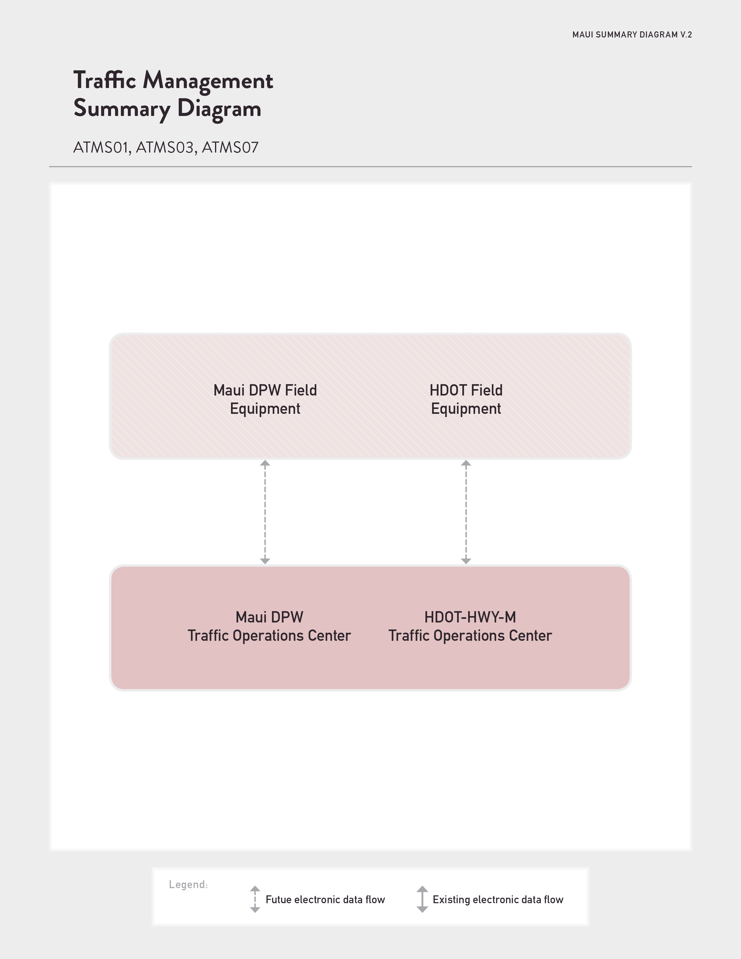
Currently on Maui, there are a number of traffic signals that are operated by the County independently from the State and vice versa. Both the County Department of Public Works and the Maui District of the HDOT Highways Division expressed their desire to have a coordinated traffic signal system that can be remotely controlled from a single, co-located traffic management center. Both agencies would like to add closed-circuit television (CCTV) cameras, dynamic message signs and other ITS field equipment that is used to enhance traffic operations, and ultimately provide real-time traffic information to the public.
Incident Management and Emergency Response
Traffic incident management consists of a planned and coordinated multi-disciplinary process to detect, respond to, and clear traffic incidents so that traffic flow may be restored as safely and quickly as possible. The summary diagram shows that the State and County plan to use new traffic devices to assist in incident detection. Already, signal pre-emption technology is used by Fire and emergency medical services (EMS) to change the traffic signal from red to green when fire trucks and ambulances are responding to a 911 call. Maui Police vehicles are equipped with mobile data terminals (MDTs) that are connected to their computer aided dispatch (CAD) system and are desired to be added to fire and EMS vehicles in the future.
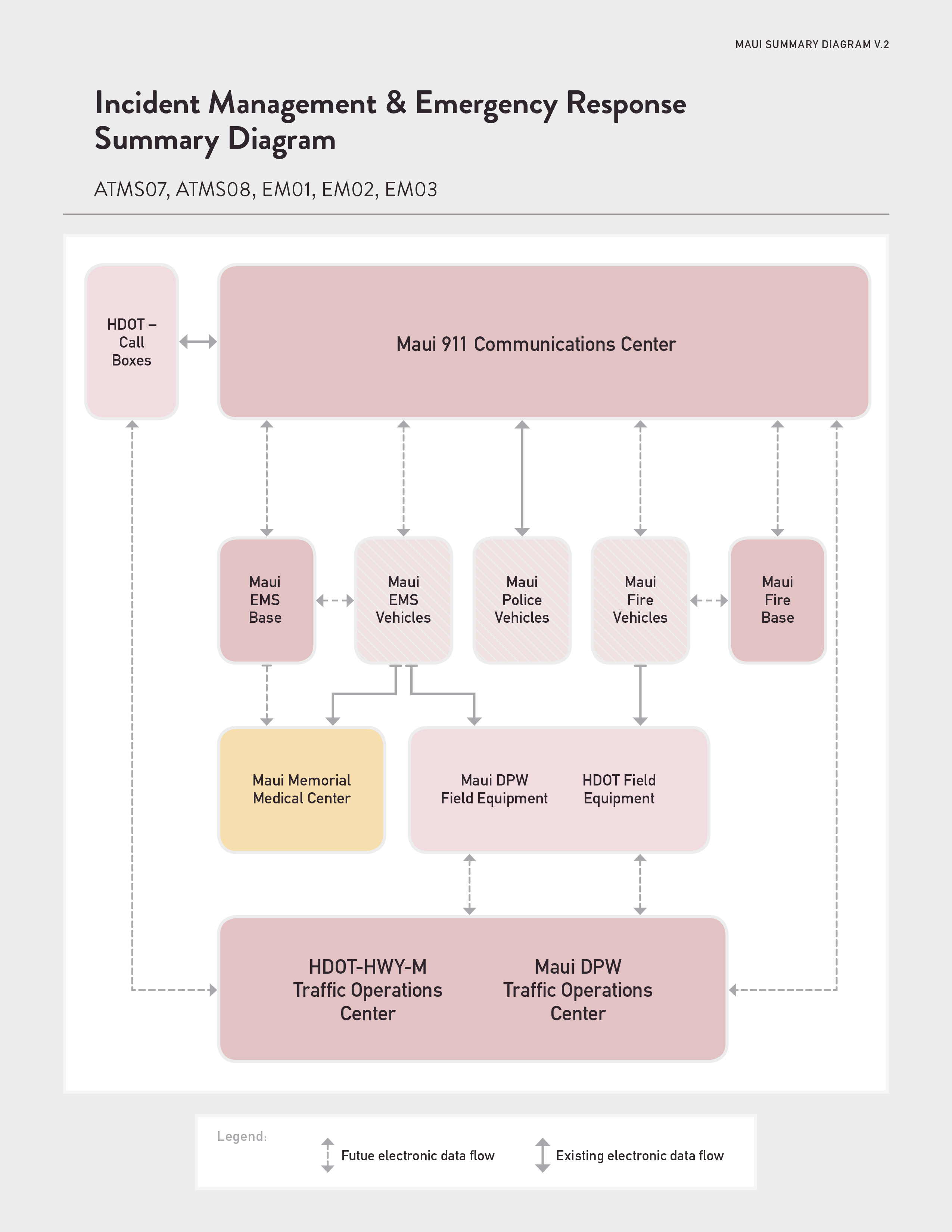
As part of a State Department of Health initiative, all ambulances on Maui are equipped with tablets that provide electronic charting for patient care prior to admission at Maui Memorial Medical Center (the island’s only hospital facility).
In many parts of the State, HDOT call boxes are being removed because of the proliferation of mobile phones and the expansion of wireless networks. However, along Maui’s Hana Highway, there are numerous areas were communications are severely limited. In these areas, the State is keeping the call boxes and is open to adding a CCTV camera at the call box location for verification purposes.
Emergency Management Disaster/Evacuation
The Disaster Response and Recovery service package enhances the ability of the surface transportation system to respond to and recover from disasters. It addresses the most severe incidents that require an extraordinary response from outside the local community. All types of disasters are addressed including natural disasters (hurricanes, earthquakes, tsunamis, etc.) and technological and man-made disasters. As shown in the summary diagram, the County’s Emergency Management Center (EOC) is at the center and coordinates between multiple agencies and entities in response and recovery. Depending on the severity of the event, representatives from public safety, human services, infrastructure agencies and private utilities each have seats at the EOC to ensure a collaborative response. The interfaces between the EOC and first responders and transportation agencies provide situational awareness and resource coordination.
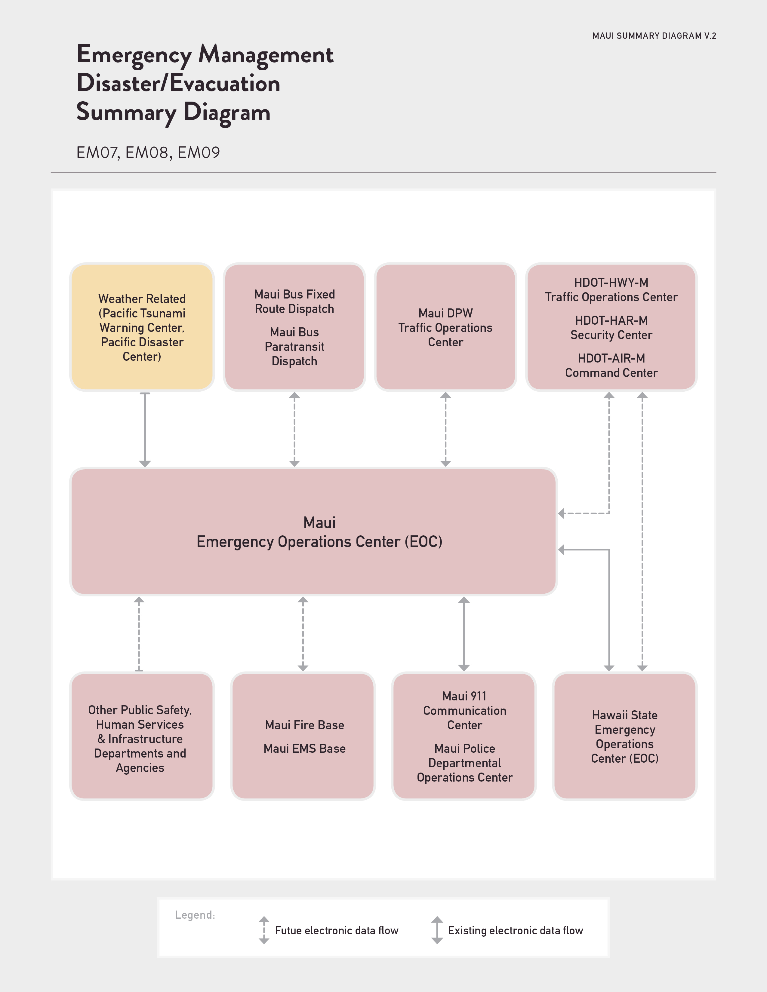
When activated, Maui’s EOC provides wide area alerts and disaster traveler information to the public electronically through its website, social media and subscription notifications. The Maui Police Department provides external access at the EOC to its 911 computer aided dispatch (CAD) system and Maui Bus assists in the evacuation of the people as needed. The HDOT Harbors Maui District is currently constructing a statewide monopole system that will allow communications between the State Harbors as well as provide a communications link to the EOC of Harbors operations during a disaster event.
Traveler Information
This summary diagram shows the collection of data -- traffic conditions, advisories, incident information and the like -- broadcast to the public. The automatically generated information is likely to include images from County and State traffic cameras, incident alerts and a congestion map. HDOT currently operates and maintains the GoAkamai traveler information system on Oahu and it is envisioned that traffic information from future ITS deployments on Maui will be published on GoAkamai’s website http://www.goakamai.org/and mobile app.
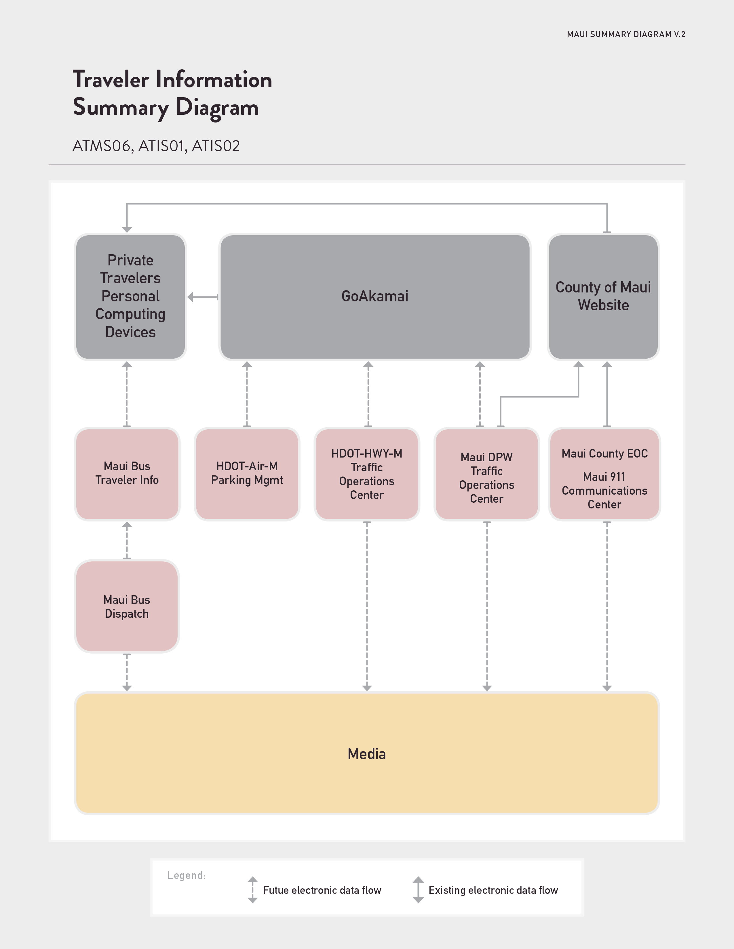
As seen in the diagram, it is envisioned that traffic and incident information will automatically be populated into GoAkamai from the existing Maui County EOC, 911 Center and future traffic operations.
In addition, GoAkamai already has the capability to provide personalized traveler information interactively – meaning that a traveler may set up a profile on GoAkamai.org to request alerts about traffic congestion, construction and incidents.
|